
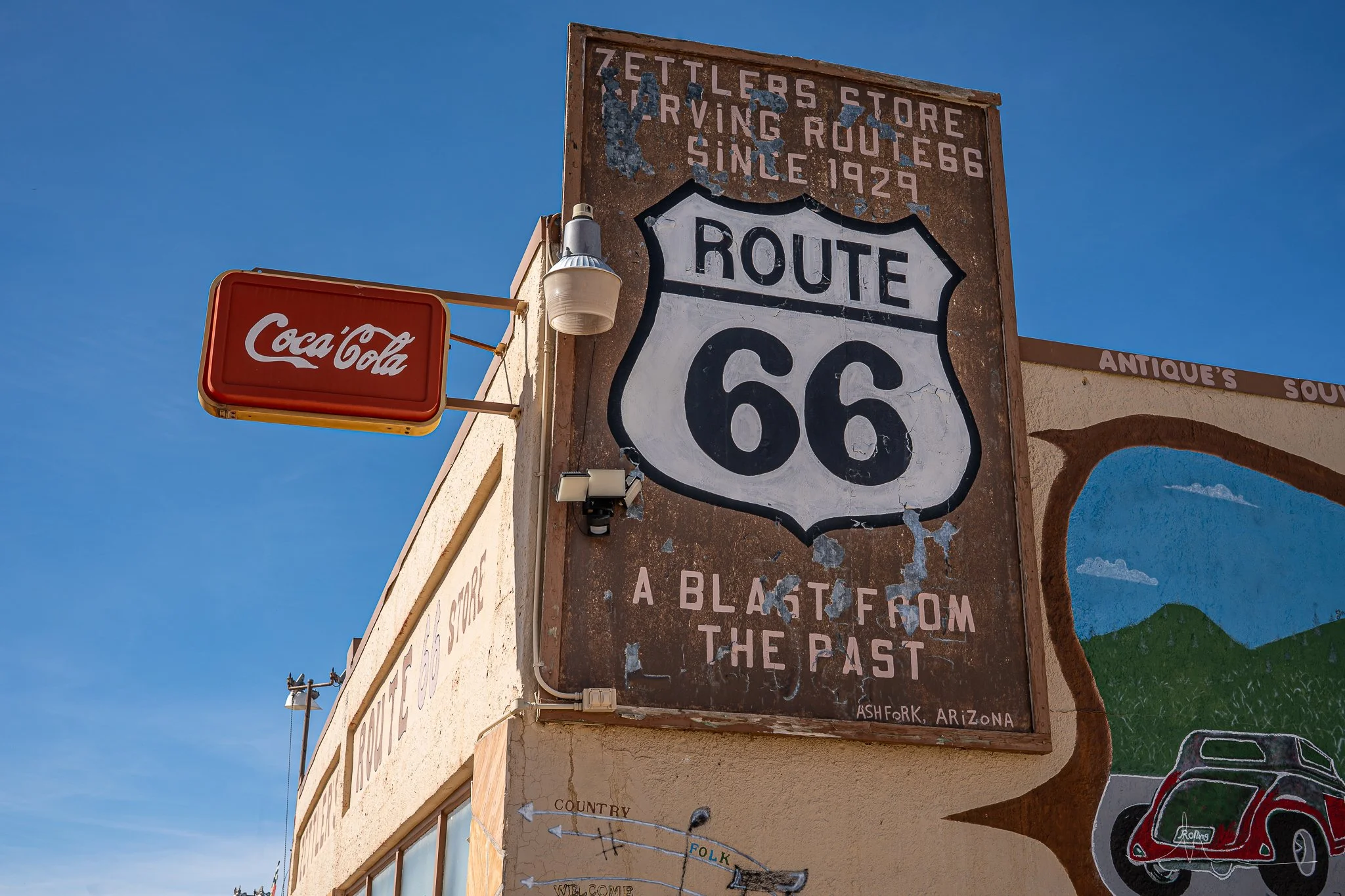
There is something special about driving a road that generations of travelers followed before you. Along Arizona's Route 66, you can still find old motor courts, neon signs, roadside diners, abandoned buildings, historic bridges, and stretches of highway that look remarkably similar to how they appeared decades ago.
But there is something many travelers don't realize until they begin planning their trip: Route 66 is no longer one continuous highway that you can simply follow from one end of Arizona to the other.
Some portions are beautifully preserved and remain open to traffic. Others have become city streets, frontage roads, or quiet stretches of pavement running alongside Interstate 40. Some original alignments have disappeared entirely, while others survive as dirt roads, abandoned roadbeds, or fragments hidden in the desert.
Understanding those differences makes exploring Route 66 much more interesting.
In 2026, Route 66 celebrates its 100th anniversary. Established on November 11, 1926, the famous highway connected Chicago with Southern California and became one of the most recognizable roads in American history. Arizona played an important role in that story, with its railroad communities, desert landscapes, trading posts, and roadside attractions welcoming generations of travelers heading west (National Park Service [NPS], n.d.-a).
Today, the Arizona Office of Tourism identifies approximately 385 miles associated with the state's historic Route 66 corridor, while the Arizona Department of Transportation (ADOT) highlights a remarkable 158-mile uninterrupted historic stretch across western Arizona (Riepl, 2026).
Whether you want to spend an afternoon exploring a single town or several days following the Mother Road across northern Arizona, there is plenty to discover.
How Route 66 became one of America's most famous highways
Before Route 66 existed, people were already traveling across northern Arizona along transportation corridors that had been used for centuries.
Indigenous peoples established routes through this landscape long before European settlement. Later, wagon roads, railroad lines, and early automobile highways followed portions of the same general east-west corridor.
One important predecessor was the National Old Trails Road, an early transcontinental automobile route. When the federal numbered highway system was established in 1926, Route 66 incorporated existing roads and connected communities that were already important transportation stops.
The highway became especially significant during the Great Depression and Dust Bowl years of the 1930s. Families leaving economically devastated areas of the Great Plains traveled west in search of work and better opportunities. Route 66 became associated with those journeys, eventually earning the nickname "Mother Road," popularized by John Steinbeck's novel The Grapes of Wrath.
Following World War II, automobile ownership and family road trips increased. Route 66 became a vacation destination in its own right.
Roadside businesses competed for travelers' attention with colorful signs, unusual architecture, souvenir shops, restaurants, and motels. Arizona's landscape provided the perfect backdrop, with the Painted Desert, Petrified Forest, mountain forests, and rugged western deserts all accessible along the journey (NPS, n.d.-a).
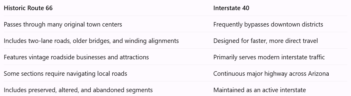
Historic Route 66 versus Interstate 40: What's the difference?
This is one of the most important things to understand before planning your trip.
Interstate 40 is the modern high-speed transportation corridor. Historic Route 66 is the older highway system that connected communities before the interstate replaced it.
The distinction becomes especially noticeable in Arizona.
When Route 66 was first established, it was not necessarily paved from end to end. Early motorists encountered rough surfaces, difficult weather, and long distances between services.
Over time, the highway was improved, paved, widened, and occasionally rerouted. This means there is not always one single "original" Route 66 alignment.
A road used in 1926 might be different from the road travelers used in 1940 or 1960.
That is why you may encounter several different historic alignments around the same community.
Why did Route 66 disappear?
The Federal-Aid Highway Act of 1956 accelerated construction of the Interstate Highway System, which was intended to provide faster, safer, higher-capacity transportation across the United States.
Instead of winding through downtown districts, new interstate highways frequently bypassed towns entirely.
For motorists traveling long distances, this was convenient. For businesses that depended on passing traffic, it could be devastating.
Gas stations, restaurants, motels, and souvenir shops that had once welcomed steady streams of customers suddenly found themselves miles from the main highway.
Some communities adapted. Others experienced substantial economic decline.
Arizona has a particularly important place in this history. Williams became the last Route 66 town in the United States to be bypassed by the interstate, in 1984.
The following year, Route 66 was officially removed from the United States Highway System.
Its story, however, was far from over (NPS, n.d.-a; Arizona Office of Tourism, n.d.-b).
Why some sections of Route 66 are gone, unpaved, or abandoned
When you look at a detailed historic Route 66 map, you may notice that the road appears to stop unexpectedly or changes from pavement to dirt.
There are several reasons for this.
Highway realignments: Engineers continually improved Route 66, straightening dangerous curves, replacing bridges, and creating more efficient routes. Older sections were sometimes abandoned decades before the interstate arrived.
Interstate construction: Portions of the original highway were incorporated into modern interstate rights-of-way. In some locations, the old road was removed, covered, or substantially altered.
Reduced maintenance: Once a roadway stopped carrying significant traffic, there was less incentive to maintain it. Some former alignments became local access roads, ranch roads, or unmaintained tracks.
Weather and erosion: Northern Arizona experiences flooding, freezing temperatures, snow, and substantial seasonal changes. Roads and bridges that are no longer maintained can deteriorate significantly.
Private property and access restrictions: Some historic roadbeds now cross private land, tribal lands, or areas where public vehicle access is restricted.
The important distinction is that an old road appearing on a historic map does not automatically mean it is legal or safe to drive today.
Some abandoned sections are best appreciated through historical photographs, interpretive exhibits, or designated viewpoints rather than attempting to follow them by vehicle.
Is all of Historic Route 66 paved?
No. Many of the popular historic sections are paved and suitable for ordinary passenger vehicles, including much of the western corridor through Seligman, Peach Springs, Hackberry, and Kingman.
However, early alignments and less-traveled remnants can be gravel, dirt, deteriorated pavement, or entirely impassable.
A historic highway designation does not guarantee that every former alignment is maintained for public driving.
For most visitors, the best experience is to combine accessible historic pavement with Interstate 40 connections rather than trying to trace every former roadbed.
Exploring Arizona's Route 66 towns from east to west
Arizona's Route 66 corridor crosses a surprisingly diverse landscape.
Beginning near the New Mexico border, the route passes through high desert, colorful badlands, railroad communities, ponderosa pine forests, open ranch country, and eventually the rugged mountains and lower deserts of western Arizona.
Each town has a different relationship with the highway. Some have beautifully restored historic districts, while others offer quiet reminders of the years when Route 66 was one of the country's busiest roads.
1. Lupton, Houck, and Sanders: Arizona's eastern gateway
The eastern portion of Arizona's Route 66 corridor receives less attention than the colorful tourist towns farther west, but it provides important context for understanding the highway's history.
Lupton sits near the New Mexico state line, where travelers entering Arizona encounter the dramatic landscapes of the Colorado Plateau.
The surrounding corridor includes trading-post history, older highway alignments, and communities shaped by the railroad and regional travel.
Houck and Sanders are smaller communities where remnants of historic transportation infrastructure are particularly interesting. The National Park Service identifies structures such as the Querino Canyon Bridge near Houck and the Sanders Bridge among Arizona's Route 66 historic resources (NPS, n.d.-a).
These places are not developed tourist destinations in the same way as Williams or Seligman.
Their appeal is quieter: older bridges, open landscapes, and opportunities to imagine what traveling across northern Arizona looked like before modern interstates.
What makes this section interesting: It shows how Route 66 served working communities and transportation networks, not just the colorful attractions that became famous in postcards.
Be mindful that surrounding areas include tribal lands and private property. Stay on authorized public roads and respect posted access restrictions.
2. Petrified Forest National Park: Where Route 66 survives as a memory
One of the most fascinating places to explore Route 66 history is Petrified Forest National Park.
It is the only national park in the National Park System containing a section of historic Route 66.
Interestingly, you cannot drive the preserved alignment through the park today.
Instead, visitors can stop at a designated roadside exhibit where an old Studebaker and a line of weathered telephone poles mark the former highway corridor.
The surrounding landscape is vast and open, making it surprisingly easy to imagine automobiles traveling across this isolated stretch decades ago.
Route 66 once carried visitors past colorful desert formations, trading posts, and the historic Painted Desert Inn.
The park offers much more than highway history, including petrified logs, ancient petroglyphs, archaeological sites, and expansive overlooks.
What makes this stop special: You can stand near the remnants of a famous highway that no longer functions as a road, surrounded by a landscape that looks largely unchanged from the early days of automobile travel.
The National Park Service explains that traces of the old roadbed and telephone poles remain visible along the former alignment (NPS, n.d.-b).
3. Holbrook: Wigwam motels, dinosaurs, and old-fashioned roadside charm
Holbrook is one of the most recognizable Route 66 towns in eastern Arizona.
Its location near Petrified Forest National Park made it an important stop for motorists traveling across the Southwest.
Today, the town is known for its roadside architecture, historic buildings, rock shops, and dinosaur-themed attractions.
One of its best-known landmarks is the Wigwam Motel, where guests stay in individual concrete structures designed to resemble tipis. The unusual accommodations are part of a historic motel chain that became associated with mid-century American road travel.
Vintage automobiles parked outside add to the nostalgic atmosphere.
Holbrook also has a long connection to Arizona's railroad and ranching history, making it more than simply a roadside tourist stop.
For photographers, it is a particularly interesting place to explore the relationship between architecture, advertising, and American automobile culture.
What makes Holbrook worth visiting: It is one of the better places in Arizona to experience the playful roadside design that helped make Route 66 famous.
Allow time to explore downtown rather than treating the Wigwam Motel as the town's only attraction.
4. Joseph City: A small community with a famous roadside landmark
West of Holbrook is Joseph City, a small community with a surprisingly memorable piece of Route 66 history.
The Jack Rabbit Trading Post became famous for its highway advertising, particularly the roadside signs that told motorists how far they were from the attraction.
The most memorable message was simple: "HERE IT IS."
The trading post's large jackrabbit figure became a popular photo opportunity.
Attractions like this illustrate an important part of Route 66 culture. Businesses often relied on creative advertising to persuade travelers to stop, especially when the next town might be many miles away.
Why stop: Joseph City offers a glimpse into the era when a clever billboard campaign could turn an otherwise ordinary roadside business into a recognizable landmark.
5. Winslow: More than a famous corner
Winslow is one of the most recognizable communities along Arizona's Route 66.
Many travelers arrive specifically to visit Standin' on the Corner Park, inspired by the Eagles' song "Take It Easy."
The park features a statue, mural, and the familiar flatbed Ford, making it one of Arizona's most photographed roadside attractions.
But Winslow has a much deeper transportation history.
The historic La Posada Hotel opened in 1930 as a Fred Harvey hotel serving railroad passengers. Designed by architect Mary Colter, it reflects an era when train travel was an important part of the American West.
Its architecture, gardens, artwork, and railroad setting make it worth visiting even if you are not staying overnight.
Downtown Winslow also contains historic storefronts and other reminders of its Route 66 past.
What makes Winslow special: It combines popular American music history with railroad heritage, architecture, and an authentic downtown environment.
Nearby attractions such as Meteor Crater and Homolovi State Park can turn a short stop into a full day of exploring.
6. Two Guns and Twin Arrows: Remnants of roadside tourism
Between Winslow and Flagstaff are two locations that tell a very different Route 66 story.
Two Guns developed as a roadside attraction near Canyon Diablo. Its history includes a former tourist complex, abandoned structures, and the remains of an old zoo.
Twin Arrows was once a recognizable trading-post and service-stop attraction, known for its enormous roadside arrows.
These places are interesting because they illustrate what happened to businesses when travel patterns changed.
Not every attraction survived the transition to interstate travel.
Some were abandoned, others deteriorated, and many became familiar landmarks for travelers interested in roadside history.
What makes these stops interesting: They reveal the less polished side of Route 66—the places that were once busy but could not remain economically viable.
Some surviving structures are unstable or located on restricted property. View them only from lawful, safe public access points. They should not be treated as open buildings for exploration.
The Arizona Office of Tourism includes both locations in its overview of Route 66 landmarks (Arizona Office of Tourism, n.d.-c).
7. Flagstaff: Route 66 in the mountains
Flagstaff offers a completely different Route 66 experience from the desert towns to the east.
At approximately 7,000 feet in elevation, Flagstaff is surrounded by ponderosa pine forests and enjoys a cooler mountain climate.
Historic Route 66 passes through the city, where vintage motel signs, historic businesses, and older commercial buildings remain part of the urban landscape.
Flagstaff was already an important railroad community before Route 66 arrived, and the highway strengthened its role as a regional transportation center.
Today, it is also known for Northern Arizona University, Lowell Observatory, nearby national monuments, and its proximity to the San Francisco Peaks.
Visitors can explore historic downtown, stop at local restaurants, and use the city as a base for surrounding attractions.
Why Flagstaff is worth including: It shows how Route 66 passed through established cities as well as small roadside communities.
It also provides a useful overnight stop for travelers exploring eastern and central Arizona.
8. Parks and Bellemont: Quieter reminders of the old highway
Between Flagstaff and Williams, the Route 66 corridor passes through forested country that looks very different from the open desert farther east.
Parks and Bellemont are associated with historic highway alignments, railroad history, and the development of northern Arizona's transportation network.
Some old-road remnants in this area are accessed by local roads and forest roads rather than a continuous designated historic highway.
The National Park Service identifies a rural Route 66 site along Forest Road 146 near Parks (NPS, n.d.-a).
For travelers who enjoy history, these quieter sections provide an opportunity to explore beyond the better-known tourist stops.
However, forest-road conditions vary seasonally. A road that is passable in dry weather may become muddy, snowy, or inaccessible at other times.
9. Williams: The last Route 66 town bypassed by the interstate
Williams has one of the most enjoyable historic downtown districts along Arizona's Route 66.
Its streets are lined with restaurants, gift shops, historic buildings, and colorful signs celebrating the highway's past.
Williams also holds an important place in transportation history.
In 1984, it became the last community on Route 66 to be bypassed by the Interstate Highway System.
That milestone effectively marked the end of Route 66's role as a continuous federal highway.
Rather than allowing its highway heritage to disappear, Williams embraced it.
Today, visitors can walk through downtown, photograph vintage signs, explore local shops, and enjoy a town that continues to celebrate its place along the Mother Road.
Williams is also the departure point for the Grand Canyon Railway, which provides passenger train excursions to the Grand Canyon's South Rim.
What makes Williams special: It combines a lively historic downtown with one of the most important final chapters in Route 66 history.
The Arizona Office of Tourism notes that the town's tourism economy continued to develop after the interstate bypass (Arizona Office of Tourism, n.d.-b).
10. Ash Fork: A railroad town shaped by changing highways
Ash Fork is easy to overlook, but its location makes it an important part of the Route 66 story.
The town developed as a railroad community and later became a stop for motorists traveling across northern Arizona.
Today, Ash Fork is associated with the stone industry, railroad heritage, and historic highway travel.
Its location also helps explain why Route 66 maps can become confusing.
Around Ash Fork, historic alignments, modern roads, and Interstate 40 do not always follow the same path.
This area marks the eastern approach to the long, largely continuous historic corridor that stretches across western Arizona.
Why visit: Ash Fork provides a quieter look at the working communities that depended on transportation long before Route 66 tourism became popular.
11. Seligman: The birthplace of Historic Route 66 preservation
Few Arizona towns are as closely associated with Route 66 preservation as Seligman.
When Interstate 40 bypassed Seligman in 1978, the community lost much of the passing traffic that had supported local businesses.
One resident, barber Angel Delgadillo, became a central figure in efforts to preserve the highway's identity.
He helped organize the Historic Route 66 Association of Arizona, which advocated for recognition of the old highway.
In 1987, Arizona designated the Seligman-to-Kingman corridor as Historic Route 66, helping inspire broader preservation and tourism efforts.
Seligman is now filled with colorful storefronts, vintage vehicles, roadside memorabilia, and businesses celebrating the highway's history.
One of its best-known attractions is Delgadillo's Snow Cap Drive-In, famous for its humorous service and old-fashioned roadside atmosphere.
What makes Seligman special: This is not simply a town that happens to sit along Route 66. It helped save the highway's identity for future generations.
The Arizona Office of Tourism recognizes Seligman as the birthplace of Historic Route 66 (Arizona Office of Tourism, n.d.-d).
12. Grand Canyon Caverns and Peach Springs: Route 66 through Hualapai country
West of Seligman, the landscape opens into broad valleys and high-desert country.
This section is particularly appealing for travelers who want to experience the feeling of driving an older highway rather than repeatedly returning to the interstate.
The Grand Canyon Caverns area is known for its underground cave system and roadside tourism history. Tours and lodging operations have changed over time, so verify what is currently available before planning a visit.
Farther west is Peach Springs, a community within the Hualapai Reservation.
Peach Springs is important both as a historic Route 66 community and as a center of Hualapai life and culture.
The surrounding region also provides access to parts of the Grand Canyon outside the heavily visited South Rim.
Diamond Creek Road, which leads toward the Colorado River, is not an ordinary unrestricted sightseeing road. Access is controlled by the Hualapai Tribe, and permits and road conditions must be checked before travel.
What makes this section special: It offers a combination of open-road scenery, living tribal culture, and a quieter side of Route 66 history.
The Hualapai Reservation is a living community, not simply a roadside attraction. Respect tribal regulations, cultural sites, and photography restrictions.
13. Truxton, Valentine, and Hackberry: Small stops with big personalities
The highway west of Peach Springs passes several small communities and former roadside stops.
Truxton developed as a highway community and still contains reminders of Route 66's commercial past.
Valentine is associated with historic railroad and highway travel, as well as nearby animal sanctuary tourism.
Hackberry is particularly popular with photographers because of the Hackberry General Store.
The property is known for vintage gas pumps, classic automobiles, weathered signs, and an extensive collection of Route 66 memorabilia.
It is one of those places where the surroundings can be as interesting as the shop itself.
What makes this section worth driving: The landscape feels open and remote, and the smaller stops help recreate the experience of traveling between communities before the interstate.
Rather than rushing from Seligman to Kingman, allow time to appreciate the road itself.
14. Kingman: One of Arizona's major Route 66 destinations
Kingman is one of the most useful destinations for travelers who want to understand Route 66 history in greater depth.
Its location made it an important transportation hub connecting northern Arizona with California, Nevada, and other parts of the Southwest.
Kingman's historic downtown includes older commercial buildings, railroad history, and businesses that reflect its role along the highway.
One of the most important attractions is the Arizona Route 66 Museum, housed in the historic Powerhouse building.
The museum explores the development of transportation across the region, including earlier travel routes and the growth of automobile tourism.
Kingman also provides convenient access to the famous mountain alignment leading toward Oatman.
Why Kingman deserves time: It offers a more substantial historical experience than a quick roadside photo stop.
For travelers interested in how the highway developed, the museum is an especially worthwhile addition.
15. Cool Springs, Sitgreaves Pass, and Oatman: One of the most dramatic drives
West of Kingman, Historic Route 66 takes a dramatic turn into the Black Mountains.
This section is among the most memorable drives along Arizona's historic highway.
The road passes Cool Springs Station, a restored roadside landmark, before climbing toward Sitgreaves Pass.
Unlike the relatively straight sections across northern Arizona, the road here becomes narrow and winding, with tight curves and substantial elevation changes.
It is a beautiful drive, but one that deserves careful attention.
Large recreational vehicles, trailers, and drivers uncomfortable with mountain roads should investigate alternative routes.
On the other side of the pass is Oatman, a former mining community that later became a Route 66 tourist destination.
Oatman is especially famous for the burros that wander through town.
The animals are associated with the area's mining history and have become one of the community's most recognizable attractions.
Visitors can walk along the historic main street, browse shops, and see buildings that reflect Oatman's mining and highway heritage.
The historic Oatman Hotel, originally the Durlin Hotel, is another notable landmark.
What makes this drive special: It provides a glimpse of the slower, more challenging travel conditions motorists experienced before modern highways crossed the desert.
According to the National Park Service, Route 66 passed through Oatman from 1926 to 1952 before a newer highway alignment diverted traffic away from the mountain town (NPS, n.d.-c).
16. Topock: Where Arizona's Route 66 reaches the Colorado River
The western end of Arizona's Route 66 journey approaches the Colorado River near Topock.
This area marks the transition from Arizona into California.
One particularly interesting historic landmark is the Old Trails Arch Bridge, which carried Route 66 traffic across the Colorado River until 1947.
The bridge later became associated with the region's transportation and infrastructure history.
Today, it is an important reminder that Route 66's route across the river changed over time.
Why Topock matters: It brings together the history of bridges, highway engineering, and the challenge of connecting automobile routes across the American Southwest.
For travelers continuing west, the journey carries on into California toward Needles and the Mojave Desert.
The best sections of Arizona Route 66 to drive in 2026
Not every mile of Arizona's historic highway offers the same experience. Some stretches are best for vintage roadside attractions, while others are more interesting for their scenery or transportation history.
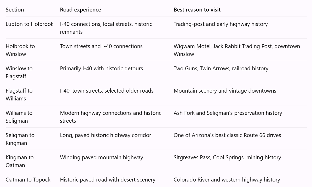
The 158-mile western corridor is particularly important because it allows visitors to experience an extended historic highway journey without repeatedly returning to the interstate. However, that figure describes a connected historic route, not 158 miles of untouched 1926 pavement (Riepl, 2026).
How to recognize the different Route 66 alignments
You may see historic maps referring to a 1926 alignment, a 1930s alignment, or a later highway alignment.
These dates tell you when a particular road served as Route 66.
A great example is Seligman. According to the National Park Service, the highway originally followed Railroad Avenue and other local streets between 1926 and 1933. After 1933, a more direct alignment along Chino Street eliminated some of the earlier turns.
Today, visitors can explore portions of both alignments. This means you can drive on historic Route 66 in the same town without necessarily following the exact road that the earliest motorists used (NPS, n.d.-e).
There is another surprising historical detail: Route 66 was not completely paved until 1938, approximately 12 years after its designation. In the 1920s and early 1930s, many western stretches were still rough, dusty, or difficult to travel during bad weather (NPS, n.d.-d).
So an unpaved historic road is not necessarily a damaged version of a once-paved highway. It might represent an alignment from the earliest era of automobile travel.
Five interesting facts about Arizona Route 66
1. Arizona helped preserve Route 66 for the entire country. Seligman's preservation movement contributed to renewed interest in the highway after its official decommissioning.
2. The highway existed before many of its famous attractions. Route 66 connected existing communities, but its popularity encouraged the development of unusual motels, trading posts, and roadside businesses.
3. The road was never completely fixed in one location. Engineers changed alignments throughout its history, meaning several different roads can legitimately claim Route 66 heritage.
4. Petrified Forest preserves a highway you cannot drive. The historic roadbed, telephone poles, and Studebaker exhibit help visitors visualize the former highway without reconstructing it as a modern road.
5. Route 66 was important to more than tourists. It carried commercial traffic, migrants, military personnel, and local residents, while also connecting communities and tribal lands across northern Arizona (NPS, n.d.-a).
Planning your Arizona Route 66 road trip
For a first-time visitor, I would recommend choosing a particular section rather than attempting to explore every historic alignment in one trip.
A two- or three-day trip through western Arizona can include Williams, Seligman, Peach Springs, Hackberry, Kingman, and Oatman.
Travelers more interested in national parks and railroad history may prefer an eastern itinerary that includes Petrified Forest, Holbrook, Winslow, and Flagstaff.
What to know before you go
Download offline maps. Cellular service can be inconsistent along remote portions of the route, especially in western Arizona.
Bring extra water. Desert temperatures can become dangerous during warmer months, and some communities have limited services.
Watch your fuel level. Fill up in larger communities rather than assuming every historic roadside stop sells gasoline.
Allow more time than your navigation app suggests. Historic Route 66 is best enjoyed at a slower pace, with time for unexpected stops.
Check the weather. Northern Arizona can experience snow and ice in winter, while summer brings high temperatures and seasonal thunderstorms.
Do not assume abandoned roads are open. Historic alignments can cross private property, tribal land, or restricted areas. Follow posted signs and verify access before entering unfamiliar roads.
Check attraction schedules. Small museums, historic businesses, tours, and roadside attractions may have limited or seasonal operating hours.
For Petrified Forest National Park, the National Park Service specifically cautions that navigation applications can incorrectly direct visitors onto remote roads or toward locked gates. A current park map is a better choice for planning your visit (NPS, n.d.-b).
Celebrating the Route 66 centennial in 2026
The centennial is a wonderful opportunity to explore Arizona's transportation history and support the communities that helped preserve it.
Throughout 2026, communities along the highway have been recognizing the anniversary through local celebrations, historical programs, and Route 66-themed activities.
The anniversary also provides an opportunity to consider what preservation really means.
A historic highway is not simply a collection of old signs and buildings. It represents the people who traveled it, the businesses that depended on it, and the communities that changed as transportation evolved.
Some of those communities are thriving tourism destinations today. Others are much quieter than they were during the highway's busiest years.
Both stories deserve to be remembered.
For official centennial information, consult the Arizona Office of Tourism, the Arizona Department of Transportation, and individual community organizers. Event dates, locations, and schedules should always be confirmed before traveling (Riepl, 2026).
The road is only part of the experience
Perhaps the most interesting thing about Arizona's Route 66 is that it is not one perfectly preserved piece of history.
It is a collection of roads, communities, memories, and landscapes that tell different parts of the same story.
In Holbrook, you can photograph a motel that reflects the creativity of mid-century roadside tourism. In Winslow, you can explore a railroad town made famous by a song. In Seligman, you can learn how local residents helped protect the highway's legacy. And near Oatman, you can experience winding mountain roads that remind you how challenging cross-country travel once was.
Some of the most meaningful stops are not the famous ones. They are the quiet stretches of pavement, weathered buildings, and forgotten roadside locations that make you wonder what life looked like when the highway was busy.
A century after its designation, Route 66 continues to offer something that modern interstate travel often overlooks: a reason to slow down and appreciate the places between destinations.
And in Arizona, there are plenty of those places worth exploring.
Follow Nicole Ford Photography for more fun in Arizona!
References
Arizona Office of Tourism. (n.d.-a). Arizona's Route 66. https://www.visitarizona.com/places/route-66
Arizona Office of Tourism. (n.d.-b). Williams. https://www.visitarizona.com/places/cities/williams
Arizona Office of Tourism. (n.d.-c). Iconic landmarks along Arizona's Route 66. https://www.visitarizona.com/like-a-local/iconic-landmarks-along-arizonas-route-66
Arizona Office of Tourism. (n.d.-d). Seligman. https://www.visitarizona.com/places/cities/seligman
National Park Service. (n.d.-a). Route 66: Arizona. https://www.nps.gov/articles/000/route-66-arizona.htm
National Park Service. (n.d.-b). Historic Route 66. Petrified Forest National Park. https://www.nps.gov/pefo/learn/historyculture/historic-route-66.htm
National Park Service. (n.d.-c). Durlin Hotel. https://www.nps.gov/places/durlin-hotel.htm
National Park Service. (n.d.-d). Route 66: 1926–1945. https://www.nps.gov/articles/route-66-1926-1945.htm
National Park Service. (n.d.-e). Seligman Historic District. https://www.nps.gov/places/seligman-historic-district.htm
Riepl, T. (2026, March 6). Route 66 centennial: Ways you can join a year of celebration. Arizona Department of Transportation. https://azdot.gov/adot-blog/route-66-centennial-ways-you-can-join-year-celebration
