
By Nicole Ford Photography
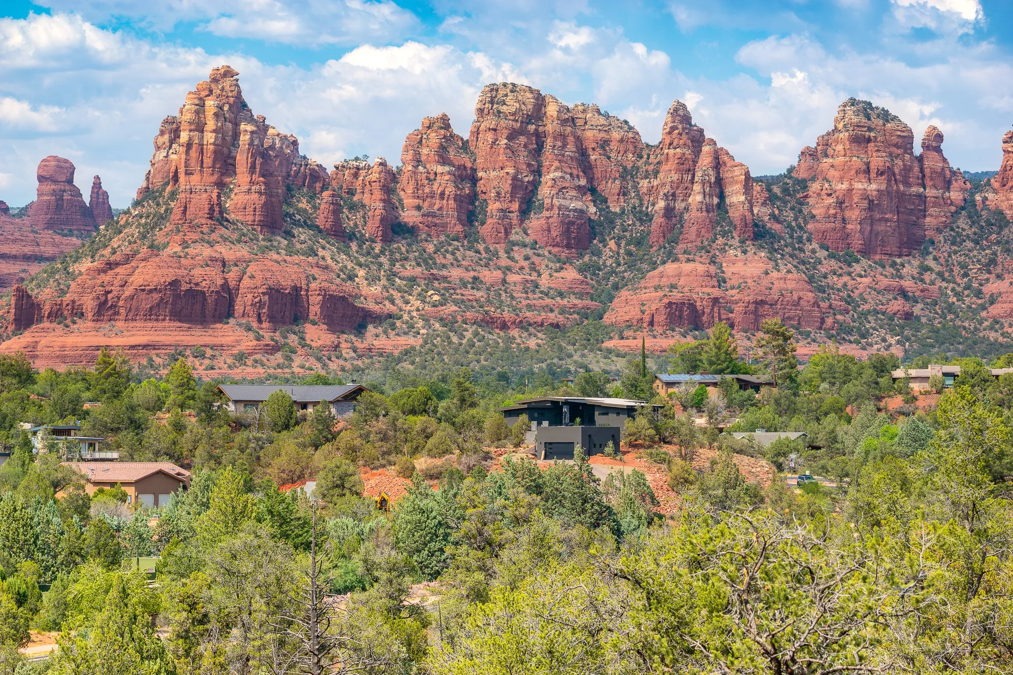
Sedona Rocks: Photo by Nicole Ford
Sedona is one of Arizona's most recognizable destinations, known for its towering red rock formations, scenic hiking trails, winding roads, and beautiful views in nearly every direction. Located in northern Arizona's Verde Valley, it offers a combination of outdoor recreation, shopping, dining, and opportunities to enjoy the surrounding landscape without necessarily committing to a difficult hike.
It is also a destination that can be surprisingly easy to overplan.
Between Cathedral Rock, Devil's Bridge, Oak Creek Canyon, and the many overlooks scattered throughout the area, visitors can quickly fill an entire weekend with activities. However, some of the most enjoyable experiences in Sedona come from allowing enough time to appreciate the scenery rather than rushing between attractions.
Whether you're planning a romantic getaway, a family weekend, or a photography trip, this guide covers some of Sedona's best places to visit, hikes worth considering, scenic drives, and practical tips for making the most of your time.
The Best Scenic Overlooks and Places to Visit in Sedona
You don't have to be an experienced hiker to enjoy Sedona. Several of its most impressive landscapes can be viewed from roadside stops, short walking paths, and established recreation areas.
1. Sedona Airport Scenic Lookout
One of Sedona's best panoramic viewpoints, the Airport Scenic Lookout overlooks the surrounding red rock formations and much of the town. It is particularly appealing in the late afternoon, when changing light brings out the colors and textures of the landscape.
From this elevated location, visitors can appreciate the scale of Sedona's surrounding formations without committing to a long hike. The views extend across the valley, with layers of sandstone creating an impressive backdrop.
Best for: Sunset photography, first-time visitors, and expansive scenery.
What to expect: A developed viewpoint near the airport with paid parking and a relatively short walk to the overlook. The area can become crowded around sunset, so arriving early is recommended.
The main overlook should not be confused with the Airport Mesa vortex viewpoint, which involves a short but rocky climb from a separate parking area.
2. Bell Rock and Courthouse Butte
Along State Route 179, Bell Rock and Courthouse Butte are among the first major landmarks many visitors encounter when approaching Sedona from the south.
Bell Rock's rounded, layered shape makes it especially recognizable, while the massive walls of Courthouse Butte create a dramatic backdrop.
The surrounding trail system allows visitors to explore the landscape at their own pace. You can take a short walk, photograph the formations from designated viewing areas, or continue farther along the trails.
Best for: Easy scenic walks, photography, and families.
What to expect: Open red rock scenery, relatively accessible trails, and excellent views without needing to climb either formation. The ground can be rocky and uneven in places.
This is one of my recommended stops for anyone visiting Sedona for the first time because it provides an excellent introduction to the area's distinctive landscape.
3. Red Rock Crossing and Crescent Moon Picnic Site
Red Rock Crossing is one of Sedona's most beautiful locations for combining water, trees, and red rock scenery.
Located along Oak Creek, the area offers views of Cathedral Rock rising above the water. Depending on creek conditions, visitors may find calm pools that reflect the surrounding sandstone formations.
The combination of cottonwood trees, flowing water, and red rock scenery makes this location feel different from Sedona's more exposed hiking trails.
Best for: Families, picnics, creekside scenery, and landscape photography.
What to expect: A developed recreation area with access to Oak Creek, picnic areas, and relatively gentle walking opportunities. Some creekside sections contain uneven rocks, exposed roots, and slippery surfaces.
The recreation area charges an entrance fee, and operating hours may vary seasonally. Visitors should check current access information before planning a sunset outing (U.S. Forest Service, n.d.).
4. Chapel of the Holy Cross
Built into Sedona's red rock landscape, the Chapel of the Holy Cross is one of the area's most distinctive architectural landmarks.
Completed in 1956, the chapel is positioned among towering sandstone formations, with a large cross incorporated into its design.
Visitors can appreciate the architecture, explore the chapel's interior during visiting hours, and enjoy elevated views of the surrounding landscape.
Best for: Architecture, photography, and shorter sightseeing stops.
What to expect: Limited parking, a steep paved approach from some parking areas, and a popular destination that can become busy during peak visiting hours.
The chapel is particularly interesting because it demonstrates how architecture can complement the surrounding landscape rather than compete with it.
5. Oak Creek Vista
North of Sedona, State Route 89A climbs through Oak Creek Canyon toward Flagstaff. Near the upper end of the canyon, Oak Creek Vista provides an elevated perspective over the winding road and forested landscape below.
The scenery here is noticeably different from the open sandstone formations around central Sedona.
Ponderosa pines, canyon walls, and a winding mountain highway create a beautiful setting, especially during autumn when deciduous trees begin changing color.
Best for: Scenic driving, fall colors, and expansive canyon views.
What to expect: A developed overlook near the top of Oak Creek Canyon with parking and viewing areas. This destination is approximately 30–45 minutes from central Sedona under favorable traffic conditions.
Oak Creek Vista makes the most sense as part of a northern scenic drive rather than a quick stop between downtown attractions.
Best Hikes in Sedona: What to Expect on the Trail
Sedona's hiking trails vary considerably in length, elevation gain, terrain, and difficulty. Some are relatively gentle walks through beautiful scenery, while others require scrambling across steep sandstone or navigating exposed ledges.
A trail's distance alone does not determine how difficult it will be.
The following are some of Sedona's most worthwhile hikes. Distances are approximate round-trip figures for common routes and may vary depending on parking locations, trail connections, and optional exploration.
1. Fay Canyon Trail
Distance: Approximately 2.4 miles round trip
Difficulty: Easy to moderate
Best for: Families, casual hikers, and canyon scenery
Fay Canyon offers a beautiful hiking experience through a sandstone canyon without requiring a major elevation gain.
The trail follows the canyon floor, passing desert vegetation, juniper trees, and towering red rock walls. As you travel farther into the canyon, the surrounding formations become more prominent, creating a sense of being enclosed within the landscape.
The scenery changes throughout the hike, with shaded areas, exposed sandstone, and opportunities to appreciate smaller details such as rock textures and desert plants.
The established trail is relatively gentle, although the surface can be rocky and uneven. Some hikers continue beyond the main trail's endpoint, but this involves rougher terrain and should not be confused with the easier maintained route.
Why this hike is special: Fay Canyon provides an opportunity to experience Sedona's towering sandstone formations from within a canyon rather than from an exposed viewpoint.
For visitors who want a rewarding hike without a strenuous climb, this is one of the area's more appealing options.
2. Cathedral Rock Trail
Distance: Approximately 1.2 miles round trip
Difficulty: Strenuous
Best for: Experienced hikers, dramatic scenery, and elevated views
Cathedral Rock is one of Sedona's most famous formations, and hiking toward its saddle provides an entirely different perspective than viewing it from the valley.
Despite its relatively short distance, this trail is physically demanding.
The route climbs steep sandstone slopes and includes sections where hikers must use their hands for balance and scrambling. Some portions involve narrow passages and exposed terrain.
Near the top, hikers reach a saddle between towering sandstone formations, where the surrounding red rock landscape opens into impressive views.
Why this hike is special: The opportunity to stand between Cathedral Rock's enormous sandstone spires creates a memorable sense of scale.
However, this trail is not suitable for everyone. Visitors uncomfortable with heights, scrambling, or steep rock surfaces should consider enjoying Cathedral Rock from Red Rock Crossing or another accessible viewpoint instead.
3. Devil's Bridge Trail
Distance: Approximately 4–6 miles round trip from common passenger-car access points
Difficulty: Moderate to strenuous
Best for: Natural arches, elevated scenery, and adventurous hikers
Devil's Bridge is one of Sedona's most photographed natural formations.
The hike travels through red rock terrain before climbing toward a large natural sandstone arch. Along the way, visitors encounter desert vegetation, sandstone formations, and increasingly expansive views.
The final portion of the trail becomes steeper, with rocky steps and uneven terrain leading toward the bridge.
At the top, visitors can see the natural arch extending across an opening in the sandstone.
Why this hike is special: Devil's Bridge offers the opportunity to view one of Sedona's most remarkable natural arches from an elevated perspective.
It is also extremely popular. Visitors should expect crowds during busy periods and may encounter lines for photographs.
Trail distance depends heavily on the starting point. The shorter approach from the upper trailhead requires traveling along a rough road unsuitable for many ordinary passenger vehicles.
4. West Fork Trail
Distance: Up to approximately 6.5 miles round trip on the commonly traveled section
Difficulty: Moderate
Best for: Shade, creek scenery, fall colors, and canyon photography
West Fork offers a very different experience from Sedona's exposed red rock trails.
Located in Oak Creek Canyon north of town, the trail follows a creek through a narrow canyon surrounded by towering sandstone walls and tall trees.
Visitors encounter repeated stream crossings, shaded sections, and beautiful views of the canyon's layered rock formations.
During autumn, the landscape becomes especially colorful as deciduous trees turn shades of yellow and orange.
Why this hike is special: West Fork combines water, forest, and sandstone scenery in one of northern Arizona's most beautiful canyon environments.
The full commonly traveled route is longer than some visitors may want to complete, but hikers can turn around earlier for a shorter outing.
Stream crossings may involve slippery rocks or wet feet, depending on water conditions. Visitors should also be aware that flash flooding can occur in narrow canyon environments.
5. Soldier Pass Trail
Distance: Approximately 4.5 miles round trip for the main out-and-back route
Difficulty: Moderate
Best for: Geological features, red rock scenery, and varied landscapes
Soldier Pass is particularly interesting because it connects several distinctive natural features within one hiking area.
One of the first major landmarks is Devil's Kitchen, a large sinkhole formed by the collapse of underground rock.
Farther along the trail, hikers reach the Seven Sacred Pools, a series of natural depressions in the sandstone that may contain water following precipitation.
The surrounding landscape includes red rock formations, desert vegetation, and views across the surrounding wilderness.
Why this hike is special: Soldier Pass offers more than a single scenic destination. Its geological features make the journey itself interesting.
Some visitors also explore a cave area reached by a separate side route, but this involves additional navigation and more challenging terrain.
The Seven Sacred Pools are not guaranteed to contain water, particularly during dry periods.
6. Bell Rock Pathway
Distance: Flexible, approximately 1–4 miles for shorter outings
Difficulty: Easy to moderate
Best for: Beginners, families, and scenic walking
Bell Rock Pathway is one of the most approachable ways to experience Sedona's red rock landscape.
Rather than climbing steeply toward a summit, the pathway travels through open terrain with impressive views of Bell Rock, Courthouse Butte, and the surrounding formations.
Visitors can choose a short walk or continue farther along the trail system.
The relatively open landscape provides numerous photography opportunities, especially when low-angle sunlight highlights the sandstone.
Why this hike is special: Bell Rock Pathway allows visitors to experience the scenery without committing to a steep or technically demanding hike.
Although it is generally more approachable than Cathedral Rock or Devil's Bridge, the surface can still be rocky and uneven.
Scenic Drives Worth Making Time For
Not every memorable experience in Sedona requires hiking. Some of the area's most beautiful landscapes can be appreciated from scenic highways and designated roadside viewpoints.
Red Rock Scenic Byway: State Route 179
State Route 179 approaches Sedona from the south, passing through the Village of Oak Creek before reaching central Sedona.
The highway offers beautiful views of Bell Rock, Courthouse Butte, and other prominent sandstone formations.
Designated trailheads and scenic stopping areas provide opportunities to leave the vehicle and appreciate the landscape.
This is one of the best drives for first-time visitors because it introduces Sedona's distinctive geology before reaching the busiest parts of town.
Oak Creek Canyon Scenic Drive: State Route 89A
Traveling north from Sedona, State Route 89A follows Oak Creek through a forested canyon before climbing steep switchbacks toward the Mogollon Rim.
The drive provides a striking contrast to the open red rock terrain around Sedona.
Visitors can enjoy views of towering canyon walls, forested slopes, and flowing water.
During autumn, changing leaves make this route particularly beautiful.
Popular stops along the corridor include West Fork Trail, designated creekside recreation areas, and Oak Creek Vista near the top of the canyon.
The road is winding, and traffic can become congested during peak travel periods.
Red Rock Loop Road
Southwest of central Sedona, Red Rock Loop Road passes through a more rural landscape with views of Cathedral Rock and nearby sandstone formations.
The drive offers opportunities to appreciate Sedona's scenery from a different perspective, including open landscapes, distant rock formations, and quieter stretches of roadway.
It is a worthwhile addition for visitors who enjoy scenic driving and photography.
Use designated pullouts when stopping and respect private property along the route.
Where to Watch the Sunset in Sedona
Sedona's sandstone formations are particularly beautiful during the final hours of daylight, when low-angle sunlight brings out their layers, colors, and textures.
However, not every viewpoint faces the same direction, and some formations fall into shadow before sunset.
Three locations are especially worth considering.
Airport Scenic Lookout
Airport Scenic Lookout is one of the most convenient choices for an expansive sunset view.
Its elevated position provides broad views across Sedona's surrounding landscape, making it an appealing destination for first-time visitors and photographers.
Because the overlook is popular, parking may become limited during the late afternoon.
Red Rock Crossing
Red Rock Crossing is especially beautiful when Cathedral Rock catches warm evening light above Oak Creek.
Photographers may find opportunities to incorporate water, trees, and sandstone reflections into their compositions.
However, visitors should confirm the recreation area's operating hours before planning an evening visit.
Bell Rock Area
Bell Rock and Courthouse Butte provide excellent opportunities to photograph changing light across large sandstone formations.
Visitors can explore established trails and choose compositions that incorporate desert vegetation, open terrain, and the surrounding mountains.
For photography, consider arriving 45–60 minutes before sunset. This provides time to observe how the light changes and find an appealing composition without rushing.
A Suggested Two-Night Sedona Itinerary
A weekend provides enough time to experience several of Sedona's highlights without attempting to visit every attraction.
The following itinerary balances outdoor activities, sightseeing, and opportunities to relax.
Day 1: Arrive and Enjoy the Scenery
Begin your visit by traveling along State Route 179 and taking time to appreciate Bell Rock and Courthouse Butte.
If you're arriving early enough, stop at a designated trailhead for a short walk and photographs.
After checking into your accommodations, spend part of the afternoon exploring Uptown Sedona.
This area contains shops, galleries, restaurants, and places to enjoy views of the surrounding red rocks.
Finish the afternoon at Airport Scenic Lookout, where you can watch the changing light across the landscape.
Day 2: Choose Your Main Hiking Adventure
Start the morning with a hike suited to your abilities.
For a relatively gentle canyon experience, consider Fay Canyon.
For a more demanding adventure, Cathedral Rock offers dramatic scenery and a challenging ascent.
After your hike, enjoy lunch and spend part of the afternoon exploring Tlaquepaque Arts & Shopping Village.
This distinctive shopping area features courtyards, galleries, specialty shops, and architecture inspired by traditional Mexican villages.
Later in the day, consider visiting Red Rock Crossing for creekside scenery, provided the recreation area remains open.
Avoid scheduling another strenuous hike simply to fill the afternoon. Leaving some flexibility makes the experience more enjoyable.
Day 3: Enjoy a Scenic Drive Before Leaving
On your final morning, take State Route 89A north through Oak Creek Canyon.
The drive passes through beautiful canyon scenery, with opportunities to appreciate forested slopes, sandstone walls, and seasonal foliage.
If time allows, stop at Oak Creek Vista near the top of the canyon.
From there, continue toward Flagstaff or return to Sedona, depending on your travel plans.
Understanding Sedona's Free Trailhead Shuttle
Parking is one of the most important practical considerations when planning a hiking trip to Sedona.
The city operates a free trailhead shuttle system serving several popular hiking areas, including Cathedral Rock, Soldier Pass, Little Horse, Mescal, and Dry Creek Vista.
Regular service generally operates Thursday through Sunday, with expanded service during certain holidays and busy travel periods. The fixed-route trailhead shuttles do not require reservations (Sedona Shuttle, n.d.-a, n.d.-b).
The principal park-and-ride locations include:
North SR 179 Park & Ride: Service toward Cathedral Rock and Little Horse.
Posse Grounds Park & Ride: Service toward Soldier Pass.
West SR 89A Park & Ride: Service toward Dry Creek Vista and Mescal.
Parking restrictions apply at certain trailheads while shuttle service is operating.
Before leaving your accommodations, confirm the correct pickup location, current shuttle schedule, and last return departure.
This is especially important when planning longer hikes, as missing the final shuttle can create significant transportation difficulties.
Practical Tips for Visiting Sedona
Start Outdoor Activities Early
Popular trailheads can become crowded, particularly during spring, fall, and holiday weekends.
Starting early may improve parking opportunities and provide more comfortable hiking temperatures.
Morning light can also be especially beautiful for photography.
Be Prepared for Changing Weather
Sedona sits at an elevation of approximately 4,300 feet, and conditions can vary significantly throughout the year.
Summer temperatures can become dangerously hot, especially on exposed sandstone trails.
Winter mornings may bring freezing temperatures, and ice can make steep rock surfaces hazardous.
Thunderstorms can develop during the summer monsoon season, creating lightning and flash-flood risks.
Always check weather forecasts before hiking.
Bring Adequate Water
Many Sedona trails offer limited shade.
Even relatively short hikes can become strenuous during warm weather, particularly when climbing exposed sandstone.
Carry enough water for everyone in your group and avoid relying on natural water sources.
Understand Parking and Recreation Fees
Some trailheads require a Red Rock Pass or another accepted recreation pass.
Other recreation areas, including certain creekside day-use sites, may charge separate entrance fees.
Pass requirements vary by location, and purchasing a pass does not guarantee an available parking space (U.S. Forest Service, n.d.).
Wear Appropriate Footwear
Sedona's hiking trails frequently contain loose gravel, uneven rock surfaces, and steep sandstone.
Shoes with reliable traction are important, even on relatively short routes.
Smooth sandstone can become slippery when wet.
Stay on Established Trails
Sedona's desert environment contains fragile soils and vegetation.
Repeated off-trail travel can damage the landscape and contribute to erosion.
Visitors should remain on established routes and follow posted regulations.
Allow Extra Driving Time
Traffic can become congested along State Routes 89A and 179, particularly during busy weekends.
Grouping nearby activities together can help reduce unnecessary driving and make the trip more enjoyable (Visit Sedona, n.d.).
Check Trail Conditions Before Visiting
Trails and recreation areas can experience temporary closures because of weather, maintenance, wildfire restrictions, or other safety concerns.
Review official updates before your planned hike or sightseeing trip.
Sedona Is Worth Enjoying at a Slower Pace
What makes Sedona special is not simply the number of attractions or famous hiking trails. It is the landscape itself.
You can spend a morning hiking between sandstone formations, enjoy lunch surrounded by red rock views, and finish the day watching the light change across the mountains.
Even a short visit can feel memorable when you allow time to appreciate your surroundings.
For first-time visitors, I recommend prioritizing a scenic drive along State Route 179, a stop at Bell Rock, one thoughtfully chosen hike, and time near Cathedral Rock or Oak Creek.
Those experiences provide a wonderful introduction to Sedona without requiring an exhausting schedule.
Whether you prefer adventurous hikes, peaceful creekside walks, or simply enjoying the scenery from a beautiful overlook, Sedona offers plenty of ways to experience one of Arizona's most remarkable landscapes.
Follow Nicole Ford Photography for more fun in Arizona.
References
Sedona Shuttle. (n.d.-a). How to ride and frequently asked questions.
Sedona Shuttle. (n.d.-b). Trailhead shuttle routes.
U.S. Forest Service. (n.d.). Coconino National Forest: Recreation.
Visit Sedona. (n.d.). Trip planning.
