
By Nicole Ford Photography
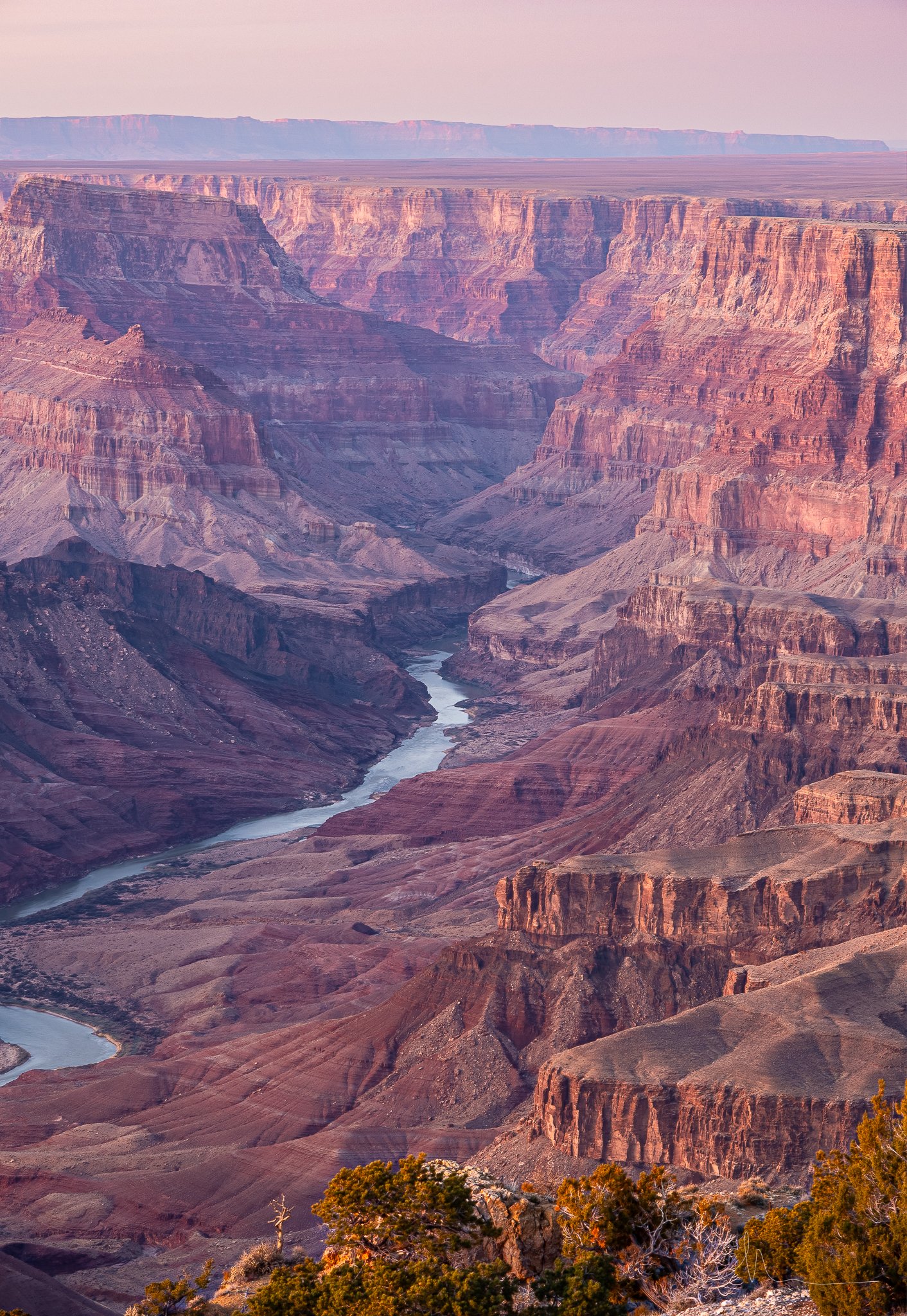
Sunset View from Desert View Watchtower at Grand Canyon South Rim: Photo by Nicole Ford
The Grand Canyon is one of Arizona's most extraordinary destinations, and while its famous overlooks attract millions of visitors, there's something special about experiencing this landscape on foot.
You don't have to hike all the way to the Colorado River to discover incredible scenery. The South Rim offers peaceful forest walks, paved pathways overlooking the canyon, historic trails carved into rock walls, and challenging descents that reveal an entirely different perspective of this natural wonder.
Some trails lead to quiet viewpoints tucked away from the busiest visitor areas. Others follow the canyon's edge, offering nearly continuous views of colorful rock formations and distant cliffs. For more adventurous visitors, short hikes below the rim provide an opportunity to experience the canyon's enormous scale from within.
I've put together 18 hiking and walking options under four miles along the Grand Canyon's South Rim, with descriptions of what makes each route interesting, what you'll encounter, and how difficult the experience will be.
Whether you're visiting with family, exploring the park for the first time, or looking for a more adventurous hike, this guide will help you find a trail that fits your interests and abilities.
South Rim Hikes Under 4 Miles: Quick Comparison
These 18 options include individual trails, short sections of the longer Rim Trail, and hikes to specific turnaround points. Several routes overlap.
Distances are approximate. One-way routes are clearly identified, and all listed round trips are under four miles. Difficulty ratings are general guidance, not official National Park Service classifications.
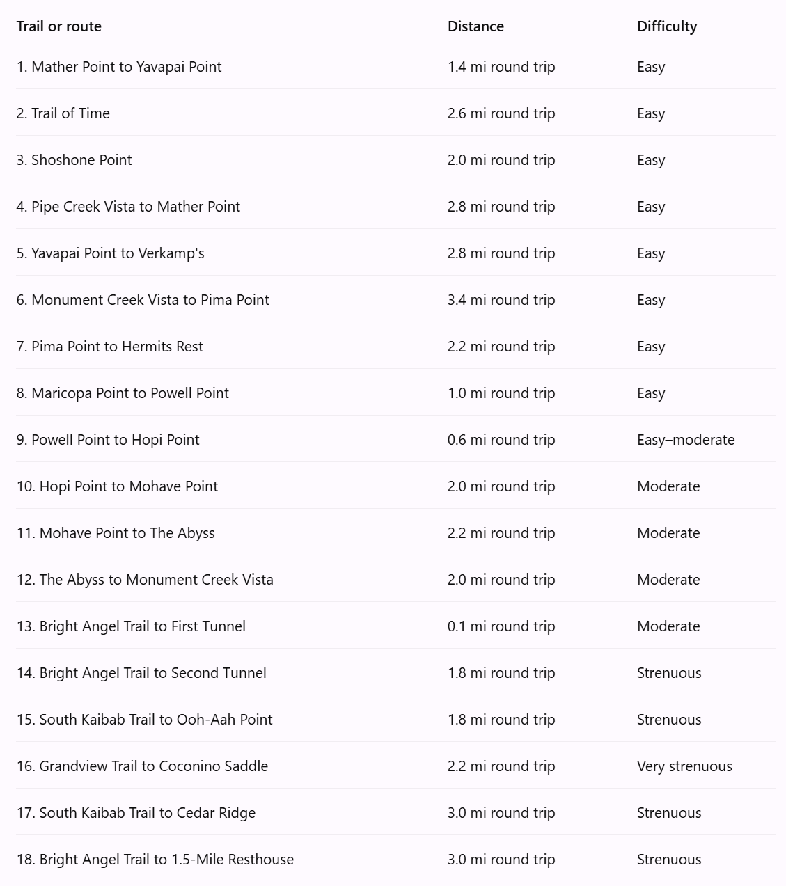
Trail mileages are planning estimates rather than surveyed measurements. Confirm your intended turnaround points and distances using current National Park Service maps.
Easy South Rim Hikes and Scenic Walks
These routes are excellent choices for visitors who want beautiful scenery without a steep descent into the canyon. Most follow established pathways with relatively modest elevation changes.
1. Mather Point to Yavapai Point
Distance: Approximately 1.4 miles round trip
Difficulty: Easy
Estimated time: 40–60 minutes
Trail type: Out and back
Surface: Paved
If you're visiting the Grand Canyon for the first time, this is one of the best places to begin exploring on foot.
Starting near Mather Point, one of the South Rim's most recognizable overlooks, the trail follows the canyon's edge toward Yavapai Point. Throughout the walk, you'll enjoy sweeping views of layered rock formations, steep cliffs, and distant ridgelines.
One of the most interesting aspects of this route is how dramatically the canyon's appearance changes as you move along the rim. Rock formations that initially appear close together begin to separate, revealing enormous valleys and hidden sections of the landscape.
The walk ends at Yavapai Point, where you'll find the Yavapai Geology Museum. Inside, exhibits explain the canyon's geological history, while large observation windows offer beautiful views of the surrounding landscape.
What makes it special: This route combines two outstanding viewpoints with one of the park's most informative museums. It's an excellent introduction to the Grand Canyon's scenery and geology.
What to expect: A developed paved walkway, interpretive information, frequent photography opportunities, and relatively large crowds near the overlooks.
2. Trail of Time
Distance: Approximately 1.3 miles one way or 2.6 miles round trip
Difficulty: Easy
Estimated time: 45–75 minutes one way, including exhibit stops
Trail type: Point to point
Surface: Paved
The Trail of Time is one of the most fascinating walks along the South Rim because it combines incredible scenery with an outdoor journey through geological history.
Beginning near Yavapai Geology Museum, the trail follows the canyon rim toward the historic Grand Canyon Village area.
Along the pathway, bronze markers embedded in the ground represent the passage of geological time. Each meter corresponds to one million years, allowing visitors to walk through a timeline representing nearly two billion years of Earth's history.
Large rock samples from different geological formations are displayed along the route. These exhibits help explain how the Grand Canyon developed and why its rock layers have such distinctive colors and textures.
The canyon itself provides a remarkable backdrop throughout the walk, with scenic viewpoints and opportunities to observe the formations discussed in the exhibits.
What makes it special: It's an outdoor geological museum where visitors can see and touch examples of the rocks that make up the Grand Canyon while learning about the enormous timescale of its formation.
What to expect: A paved pathway, educational exhibits, canyon overlooks, and opportunities to stop and read interpretive signs. This is an especially rewarding walk for families and visitors interested in natural history.
3. Shoshone Point Trail
Distance: Approximately 2 miles round trip
Difficulty: Easy
Estimated time: 45–75 minutes
Trail type: Out and back
Surface: Unpaved forest road
Shoshone Point is one of the South Rim's more peaceful hiking experiences, particularly for visitors who want to escape the busiest developed overlooks.
Located off Desert View Drive, the route begins along a wide dirt road surrounded by ponderosa pines, pinyon pines, and juniper trees.
Unlike many South Rim walks, you won't have continuous canyon views along the way. Instead, the first portion of the hike feels more like a quiet forest stroll.
That changes dramatically as you approach the viewpoint.
The trees eventually open to reveal a spectacular panorama of the Grand Canyon, with colorful rock formations, distant cliffs, and deep valleys stretching across the landscape.
The contrast between the peaceful woodland and the sudden canyon view makes this trail particularly memorable.
Shoshone Point also serves as a designated event and picnic area, so access may occasionally be restricted for permitted gatherings.
What makes it special: The dramatic reveal of the canyon after a peaceful forest walk, along with the opportunity to experience a less-developed viewpoint.
What to expect: A relatively level dirt road, shaded sections through the forest, and an exposed canyon viewpoint without protective railings. Stay well back from the edge.
4. Pipe Creek Vista to Mather Point
Distance: Approximately 1.4 miles one way or 2.8 miles round trip
Difficulty: Easy
Estimated time: 35–60 minutes one way
Trail type: Point to point
Surface: Paved
This section of the Rim Trail is a wonderful option for visitors who want to experience the canyon at a slower pace.
Beginning at Pipe Creek Vista, the route follows the South Rim toward Mather Point, offering views into the canyon along much of the way.
The landscape features scattered trees, open rock formations, and changing perspectives of the cliffs below.
One of the advantages of walking this section is the opportunity to appreciate details that are easy to overlook when traveling between viewpoints by vehicle.
You'll notice the shapes of individual rock formations, the way shadows move across the canyon walls, and how the landscape changes as you approach Mather Point.
What makes it special: It's an enjoyable way to experience one of the Grand Canyon's most popular areas without spending the entire visit at crowded overlooks.
What to expect: A paved walking route, exposed sunny sections, scenic viewpoints, and increasing visitor activity as you approach Mather Point.
5. Yavapai Point to Verkamp's Visitor Center
Distance: Approximately 1.4 miles one way or 2.8 miles round trip
Difficulty: Easy
Estimated time: 40–70 minutes one way
Trail type: Point to point
Surface: Paved
This walk connects the geological attractions around Yavapai Point with the historic heart of Grand Canyon Village.
The route overlaps the Trail of Time, so visitors will encounter geological exhibits, rock samples, and informational displays explaining the canyon's formation.
As you approach the village, the scenery begins to include historic buildings and developed visitor areas.
Verkamp's Visitor Center occupies a historic building near the canyon rim and offers exhibits relating to the Grand Canyon's human history.
This makes the walk particularly interesting for visitors who want to learn about both the natural landscape and the people who have lived, worked, and traveled through the area.
What makes it special: The combination of geological interpretation, historic buildings, and beautiful canyon scenery.
What to expect: A paved walkway, interpretive exhibits, occasional crowds, and convenient access to Grand Canyon Village facilities.
6. Monument Creek Vista to Pima Point
Distance: Approximately 1.7 miles one way or 3.4 miles round trip
Difficulty: Easy
Estimated time: 40–70 minutes one way
Trail type: Point to point
Surface: Paved Greenway Trail
This section of the South Rim is an excellent choice for visitors looking for a peaceful walk with impressive canyon views.
Located along Hermit Road, the route follows the paved Greenway Trail between Monument Creek Vista and Pima Point.
The scenery includes open stretches of canyon rim, scattered vegetation, and broad views of the rugged formations below.
As you approach Pima Point, the landscape opens to reveal portions of the Colorado River winding through the canyon.
Pima Point is particularly interesting because the river is visible far below, and under quiet conditions, visitors may even hear the distant sound of rapids.
The paved Greenway Trail is designed for a wider range of visitors than the rugged unpaved sections of the Rim Trail, although grades and conditions still need to be considered.
What makes it special: The opportunity to enjoy a relatively peaceful paved walk and finish at one of the South Rim's impressive Colorado River viewpoints.
What to expect: A paved pathway, exposed sunny areas, broad canyon views, and access to seasonal Hermit Road shuttle stops.
7. Pima Point to Hermits Rest
Distance: Approximately 1.1 miles one way or 2.2 miles round trip
Difficulty: Easy
Estimated time: 25–45 minutes one way
Trail type: Point to point
Surface: Paved Greenway Trail
This scenic walk connects Pima Point with Hermits Rest, one of the most interesting historic destinations along the South Rim.
Beginning at Pima Point, you'll have an opportunity to enjoy expansive canyon views and look toward sections of the Colorado River.
The paved pathway then continues toward Hermits Rest through a landscape of scattered trees and canyon-rim scenery.
At the end of the walk, you'll arrive at the historic Hermits Rest building, designed by architect Mary Colter and completed in 1914.
The stone structure was designed to blend into its natural surroundings, with rustic architectural details that reflect the character of the landscape.
Visitors can explore the area, admire the building, and take a break before returning.
What makes it special: The combination of scenic walking, Colorado River views, and one of the Grand Canyon's most recognizable historic buildings.
What to expect: A paved pathway, gentle changes in elevation, open views, and a developed destination at Hermits Rest.
8. Maricopa Point to Powell Point
Distance: Approximately 0.5 miles one way or 1 mile round trip
Difficulty: Easy
Estimated time: 15–25 minutes one way
Trail type: Point to point
Surface: Paved
This short section of the Rim Trail connects two viewpoints with beautiful scenery and interesting historical significance.
Maricopa Point offers expansive views across the canyon, including the rugged cliffs and formations that characterize the western South Rim.
As you continue toward Powell Point, the pathway follows the rim through an area with frequent opportunities to stop and appreciate the landscape.
Powell Point is home to a memorial honoring John Wesley Powell, who led pioneering expeditions through the Colorado River corridor during the nineteenth century.
The memorial adds an interesting historical dimension to the walk, particularly for visitors curious about early exploration of the Grand Canyon.
What makes it special: Two beautiful viewpoints connected by a short walk, with an opportunity to learn about the canyon's exploration history.
What to expect: A relatively short paved route, canyon overlooks, and access to Hermit Road shuttle stops.
Moderate South Rim Hikes and Natural Rim Trails
These routes offer a slightly more rugged experience than the paved walks near Grand Canyon Village. Although they remain relatively short, some feature uneven ground, exposed canyon edges, and narrower dirt pathways.
9. Powell Point to Hopi Point
Distance: Approximately 0.3 miles one way or 0.6 miles round trip
Difficulty: Easy to moderate
Estimated time: 10–20 minutes one way
Trail type: Point to point
Surface: Unpaved
This short stretch of the Rim Trail connects Powell Point with Hopi Point, one of the South Rim's most popular sunset destinations.
The pathway follows the canyon rim, offering impressive views of layered cliffs and distant rock formations.
Unlike the developed paved sections near Grand Canyon Village, this stretch has a more natural trail surface, creating a slightly more rugged walking experience.
Hopi Point extends outward from the rim, providing broad views in multiple directions.
During the late afternoon, sunlight begins illuminating different sections of the canyon, creating dramatic contrasts between brightly lit rock formations and deep shadows.
What makes it special: The opportunity to walk between two excellent viewpoints and finish at one of the Grand Canyon's most celebrated sunset locations.
What to expect: A short dirt trail, uneven footing, exposed sections near the rim, and potentially large crowds at Hopi Point around sunset.
10. Hopi Point to Mohave Point
Distance: Approximately 1 mile one way or 2 miles round trip
Difficulty: Moderate
Estimated time: 30–50 minutes one way
Trail type: Point to point
Surface: Unpaved
For visitors interested in photography, this is one of the most rewarding sections of the western Rim Trail.
Beginning at Hopi Point, the pathway follows the canyon rim toward Mohave Point, offering constantly changing views of the surrounding landscape.
Along the way, you'll encounter dramatic cliffs, distant ridgelines, and expansive views across the canyon.
The landscape feels especially impressive where the trail opens toward the deeper sections of the canyon.
Mohave Point offers views toward the Colorado River and the rugged formations surrounding it.
This section can be particularly beautiful during the late afternoon, when sunlight creates strong contrasts between the canyon's colorful rock layers.
What makes it special: The opportunity to experience two outstanding viewpoints while enjoying a more natural walking trail between them.
What to expect: Uneven dirt pathways, exposed areas, limited shade, and numerous opportunities for scenic photography.
11. Mohave Point to The Abyss
Distance: Approximately 1.1 miles one way or 2.2 miles round trip
Difficulty: Moderate
Estimated time: 30–55 minutes one way
Trail type: Point to point
Surface: Unpaved
This section of the Rim Trail leads toward one of the South Rim's most dramatic viewpoints.
Beginning at Mohave Point, the trail follows the canyon's edge through a landscape of scattered vegetation, rocky terrain, and open viewpoints.
As you approach The Abyss, the canyon walls become particularly impressive.
The Abyss is known for its dramatic vertical drop, with steep cliffs descending toward the formations below.
Standing at the designated viewpoint provides an extraordinary sense of the Grand Canyon's depth and scale.
For photographers, this section offers opportunities to capture towering rock walls, layered formations, and dramatic shadows.
What makes it special: The dramatic scenery at The Abyss and the opportunity to appreciate the canyon's enormous vertical scale.
What to expect: A natural dirt pathway, uneven footing, exposed canyon edges, and limited shade. Stay on the designated trail and away from unstable edges.
12. The Abyss to Monument Creek Vista
Distance: Approximately 1 mile one way or 2 miles round trip
Difficulty: Moderate
Estimated time: 30–50 minutes one way
Trail type: Point to point
Surface: Unpaved
This route connects the dramatic cliffs of The Abyss with the scenic overlook at Monument Creek Vista.
The trail follows the rim through a landscape of rocky outcrops, scattered vegetation, and open canyon views.
One of the interesting features of this section is the changing character of the terrain.
The route begins near the steep cliffs of The Abyss and gradually transitions toward the more developed Greenway Trail near Monument Creek Vista.
Along the way, visitors can enjoy views of the rugged formations surrounding Monument Creek's drainage.
What makes it special: The contrast between the dramatic cliff scenery at The Abyss and the broader canyon landscape approaching Monument Creek Vista.
What to expect: A narrower natural trail, uneven ground, exposed areas, and opportunities to continue onto the paved Greenway Trail.
Short but Strenuous Hikes Below the South Rim
The following routes descend into the Grand Canyon rather than remaining along its upper edge.
These hikes offer a completely different experience, with steep switchbacks, towering canyon walls, and changing perspectives of the surrounding formations.
However, they are significantly more challenging than their distances might suggest.
Remember that every foot of elevation lost on the descent must be regained on the return climb.
13. Bright Angel Trail to First Tunnel
Distance: Approximately 0.1 miles round trip
Difficulty: Moderate due to the steep grade
Estimated time: 15–25 minutes
Trail type: Out and back
Surface: Rocky, maintained trail
The Bright Angel Trail is one of the most famous hiking routes in Grand Canyon National Park, and even its uppermost section offers an interesting introduction to hiking below the rim.
Beginning near Bright Angel Lodge, the trail immediately descends through a series of switchbacks carved into the canyon walls.
The First Tunnel is located a short distance below the trailhead and is one of the trail's recognizable historic features.
Walking through the tunnel provides an opportunity to appreciate the engineering involved in constructing trails through such steep terrain.
Although this is a very short walk, the descent quickly reveals how different hiking below the rim feels compared with strolling along the developed overlooks.
What makes it special: A brief introduction to the historic Bright Angel Trail and an opportunity to experience the canyon from just below the rim.
What to expect: A steep rocky trail, switchbacks, uneven footing, and an uphill return.
14. Bright Angel Trail to Second Tunnel
Distance: Approximately 1.8 miles round trip
Difficulty: Strenuous
Estimated time: 1–2 hours
Trail type: Out and back
Elevation change: Approximately 590 feet
For visitors who want to venture farther below the South Rim without committing to a long-distance hike, the Second Tunnel offers an interesting turnaround destination.
The trail begins near Bright Angel Lodge and descends through a series of switchbacks along the canyon walls.
As you move farther below the rim, the surrounding rock formations become more prominent, and the perspective of the canyon changes.
Rather than looking down into the landscape from above, you'll begin to feel surrounded by the canyon's towering walls.
The Second Tunnel is another recognizable feature of the historic trail, providing a memorable destination before beginning the climb back to the rim.
What makes it special: The opportunity to experience the canyon's rock walls up close and follow one of its most historic hiking routes.
What to expect: Steep switchbacks, rocky footing, increasing sun exposure, and a demanding uphill return.
15. South Kaibab Trail to Ooh-Aah Point
Distance: Approximately 1.8 miles round trip
Difficulty: Strenuous
Estimated time: 1–2 hours
Trail type: Out and back
Elevation change: Approximately 790 feet
Ooh-Aah Point is one of the most memorable short hikes below the South Rim.
The South Kaibab Trail begins near Yaki Point and immediately descends through steep switchbacks carved into the canyon walls.
At first, much of the scenery is framed by the surrounding cliffs. As you continue descending, the landscape gradually begins to open.
Then, as the trail rounds a bend near Ooh-Aah Point, the canyon suddenly reveals itself in an enormous panorama of colorful cliffs, distant ridgelines, and deep valleys.
The dramatic reveal is what makes this destination so popular.
Unlike many of the developed overlooks along the rim, Ooh-Aah Point gives visitors a sense of being within the canyon rather than simply observing it from above.
What makes it special: The sudden panoramic reveal and the opportunity to experience the Grand Canyon from below its rim.
What to expect: Steep switchbacks, rocky footing, significant sun exposure, and a strenuous uphill return. There is no drinking water along the South Kaibab Trail.
16. Grandview Trail to Coconino Saddle
Distance: Approximately 2.2 miles round trip
Difficulty: Very strenuous
Estimated time: 2–4 hours
Trail type: Out and back
Elevation change: Approximately 1,000 feet
Grandview Trail is one of the South Rim's most rugged and historically interesting hiking routes.
Beginning at Grandview Point along Desert View Drive, the trail descends steeply through rocky terrain and narrow switchbacks.
The route follows portions of a historic mining trail, and remnants of old cobblestone construction remain visible along sections of the descent.
Unlike the heavily maintained Bright Angel and South Kaibab corridor trails, Grandview Trail has a more primitive character.
The terrain is steep, rocky, and sometimes exposed, requiring careful footing and a willingness to navigate challenging sections.
Coconino Saddle provides a natural turnaround point with impressive views of the surrounding canyon formations.
What makes it special: Historic mining-era trail construction, rugged terrain, and dramatic canyon scenery away from the most heavily traveled corridor routes.
What to expect: Very steep grades, loose rock, uneven steps, exposed sections, and a difficult climb back to Grandview Point. This route is best suited to experienced hikers.
17. South Kaibab Trail to Cedar Ridge
Distance: Approximately 3 miles round trip
Difficulty: Strenuous
Estimated time: 2–4 hours
Trail type: Out and back
Elevation change: Approximately 1,120 feet
Cedar Ridge is one of the most rewarding destinations for hikers looking to experience a substantial section of the South Kaibab Trail.
After descending through the upper switchbacks and passing Ooh-Aah Point, the trail continues toward a broad ridge surrounded by extraordinary canyon scenery.
The landscape opens dramatically as you approach Cedar Ridge, with colorful rock formations extending in nearly every direction.
From this location, hikers can appreciate the immense scale of the canyon and observe how its different geological layers create the distinctive cliffs and terraces visible throughout the park.
Cedar Ridge also provides a place to stop, rest, and enjoy the views before beginning the climb back toward the rim.
What makes it special: The feeling of being surrounded by the Grand Canyon, with panoramic views that extend far beyond those available from the developed overlooks.
What to expect: Steep switchbacks, rocky terrain, very limited shade, and a demanding uphill return. Toilet facilities are available at Cedar Ridge, but there is no drinking water along the trail.
18. Bright Angel Trail to 1.5-Mile Resthouse
Distance: Approximately 3 miles round trip
Difficulty: Strenuous
Estimated time: 2–4 hours
Trail type: Out and back
Elevation change: Approximately 1,120 feet
The 1.5-Mile Resthouse is one of the most recognizable turnaround destinations along Bright Angel Trail.
Beginning near Bright Angel Lodge, the route descends through a series of switchbacks carved into the canyon walls.
As you continue downward, the developed village area gradually disappears from view, replaced by towering rock formations and increasingly dramatic perspectives of the canyon.
One of the most interesting aspects of this hike is the opportunity to observe the canyon's geological layers from within the landscape.
Rock formations that appeared as distant bands from the rim become enormous walls surrounding the trail.
The resthouse provides a designated stopping point before the strenuous climb back to the South Rim.
What makes it special: A memorable below-rim hiking experience on one of the Grand Canyon's most historic trails, with impressive rock formations and dramatic elevation changes.
What to expect: Steep switchbacks, rocky footing, limited shade, and a challenging uphill return. Water service at the resthouse is seasonal and should never be assumed available.
Which Grand Canyon South Rim Hike Should You Choose?
With so many options, choosing the right hike depends on what kind of experience you're looking for.
For families and first-time visitors: Mather Point to Yavapai Point and the Trail of Time are excellent choices. Both combine spectacular scenery with educational opportunities and relatively manageable walking conditions.
For a quieter experience: Shoshone Point offers a peaceful forest walk leading to a beautiful canyon overlook.
For photography: Hopi Point to Mohave Point provides changing canyon perspectives, while the Monument Creek Vista to Pima Point route offers excellent opportunities to photograph the Colorado River.
For an adventurous short hike: South Kaibab Trail to Ooh-Aah Point provides an unforgettable below-rim experience, although the steep climb makes it considerably more demanding than its mileage suggests.
For experienced hikers: Grandview Trail to Coconino Saddle offers rugged terrain, historic trail construction, and impressive canyon scenery.
Important Tips for Hiking the Grand Canyon South Rim
The Grand Canyon's South Rim sits at approximately 7,000 feet above sea level, and the elevation can affect visitors who aren't accustomed to hiking at higher altitudes.
Weather conditions also vary dramatically throughout the year.
Summer brings intense sunlight and potentially dangerous heat, particularly below the rim. Winter can produce snow, ice, and slippery trail conditions.
Even short hikes require preparation.
Bring adequate drinking water, snacks, sun protection, and sturdy footwear. For below-rim hikes, allow plenty of time for the return climb and avoid beginning a descent when conditions are unfavorable.
The National Park Service emphasizes that there are no easy trails into or out of the Grand Canyon.
If you're unsure about your physical ability or the day's weather, choosing a scenic walk along the rim can be just as rewarding as descending into the canyon.
Final Thoughts
One of the things I appreciate most about the Grand Canyon is how many different ways there are to experience it.
You can spend an hour walking along a paved pathway with incredible views, explore a peaceful forest trail leading to a secluded overlook, or challenge yourself with a steep descent into the canyon.
Each experience offers something different.
The Rim Trail provides constantly changing perspectives of the canyon's enormous landscape, while routes like Shoshone Point offer a quieter connection with the surrounding forest.
For adventurous hikers, destinations like Ooh-Aah Point and Cedar Ridge reveal an entirely different side of the Grand Canyon.
You don't need to hike for miles to find something extraordinary here. Sometimes, a short walk and a little extra time to appreciate the scenery are all you need.
Before You Go: Grand Canyon trails may experience temporary or seasonal closures due to weather, maintenance, rockfalls, or other safety concerns. Trail conditions, shuttle operations, and water availability can change throughout the year. Before your planned hike, check the National Park Service Grand Canyon website for the latest information.
Follow Nicole Ford Photography for more fun in Arizona.
References
National Park Service. (n.d.). Day hiking. https://www.nps.gov/grca/planyourvisit/day-hiking.htm
National Park Service. (n.d.). Backcountry trail distances. https://www.nps.gov/grca/planyourvisit/trail-distances.htm
National Park Service. (n.d.). Bright Angel Trail. https://www.nps.gov/places/000/bright-angel-trail.htm
National Park Service. (n.d.). Day hiking the Grandview Trail. https://www.nps.gov/grca/planyourvisit/upload/GrandviewTrail.pdf
National Park Service. (n.d.). Day hiking the Rim Trail. https://www.nps.gov/grca/planyourvisit/upload/rimtrail.pdf
National Park Service. (n.d.). Day hiking the South Kaibab Trail. https://www.nps.gov/grca/planyourvisit/upload/SouthKaibabTrail.pdf
National Park Service. (n.d.). Shoshone Point parking area. https://www.nps.gov/places/000/shoshone-point-parking-area.htm
National Park Service. (n.d.). The Trail of Time. https://www.nps.gov/grca/planyourvisit/the-trail-of-time.htm
National Park Service. (n.d.). South Rim shuttle bus routes. https://www.nps.gov/grca/planyourvisit/shuttle-buses.htm
